A couple of hours south of Bryce Canyon is Zion National Park. The colors of the rocks are similar, but they couldn't be more different. The way the water flows through the valley meadows, the waterfalls, and the steep walls are more reminiscent of Yosemite, the GRANDEST park. Zion is beautiful.

I was here briefly in 1972, and in my mind's eye, this view is what I see:

Zion began a shuttle system for park visitors in 1997. It is free with many stops where you can get off and get on to go in either direction. The afternoon we arrived, we rode the shuttle to get an overview. On the way up the canyon you hear the stories, marvel at the cliffs and the waterfalls, and decide where to go first the next day. Since it was late in the afternoon, on the way down the canyon we saw mule deer, vultures, and wild turkeys along with our first introduction to Angels Landing, our destination for the next day.

First we took the Riverside Hike of 2.2 miles at the top of the canyon. It had rained recently, and the Virgin River was in full flow. Then we headed back down canyon. At one stop a ranger had a telescope pointing to rock climbers. She also told us that California Condors can be seen in the park, but none had been spotted today.
Then because our friend Chuck said it was a great hike, we decided to go to Angels Landing. Remember that we had hiked down into Bryce Canyon yesterday? Well, the wimp hiker that I am, wasn't too keen on the idea. However, I realized we would be going up first, then down. I said I would go as far as I was able, and we began the climb. Well, we climbed, and I kept going...up, up, up. The path was steep, but doable because the trail that had been created in 1926, was concrete, not dirt and rocks. Of course, it was too hard to think about taking any photos with all my puffing, pausing, puffing, and putting one foot in front of the other. My eyes were fixated on the next bit to do and keeping away from the edge. After some time and Walter's Wiggles, we arrived at Scout Lookout. WOW! We had climbed the major portion of the hike...nearly 2 miles up 1400 feet. The last half mile to the summit was via a dirt and sandstone path with the occasional chain. Boyo said he had had enough, but I was welcome to go ahead. I did start out, but at this point I was too tired, too shaky to continue. Maybe if we had not done the Riverside Hike earlier....
And after a brief rest, we headed down...which is when I could finally take some photos.

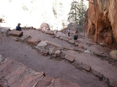
This is the beginning of the last half mile. Note the sign about how you could easily fall down the 1000 foot drop-offs on either side. I also did not like how there were really a lot of people on the narrow trail.

Walter's Wiggles
21 Switchbacks

Up Canyon

Down Canyon

A Backward Glance

Are We There Yet?

I was here briefly in 1972, and in my mind's eye, this view is what I see:

Zion began a shuttle system for park visitors in 1997. It is free with many stops where you can get off and get on to go in either direction. The afternoon we arrived, we rode the shuttle to get an overview. On the way up the canyon you hear the stories, marvel at the cliffs and the waterfalls, and decide where to go first the next day. Since it was late in the afternoon, on the way down the canyon we saw mule deer, vultures, and wild turkeys along with our first introduction to Angels Landing, our destination for the next day.

First we took the Riverside Hike of 2.2 miles at the top of the canyon. It had rained recently, and the Virgin River was in full flow. Then we headed back down canyon. At one stop a ranger had a telescope pointing to rock climbers. She also told us that California Condors can be seen in the park, but none had been spotted today.
Then because our friend Chuck said it was a great hike, we decided to go to Angels Landing. Remember that we had hiked down into Bryce Canyon yesterday? Well, the wimp hiker that I am, wasn't too keen on the idea. However, I realized we would be going up first, then down. I said I would go as far as I was able, and we began the climb. Well, we climbed, and I kept going...up, up, up. The path was steep, but doable because the trail that had been created in 1926, was concrete, not dirt and rocks. Of course, it was too hard to think about taking any photos with all my puffing, pausing, puffing, and putting one foot in front of the other. My eyes were fixated on the next bit to do and keeping away from the edge. After some time and Walter's Wiggles, we arrived at Scout Lookout. WOW! We had climbed the major portion of the hike...nearly 2 miles up 1400 feet. The last half mile to the summit was via a dirt and sandstone path with the occasional chain. Boyo said he had had enough, but I was welcome to go ahead. I did start out, but at this point I was too tired, too shaky to continue. Maybe if we had not done the Riverside Hike earlier....
And after a brief rest, we headed down...which is when I could finally take some photos.

This is the beginning of the last half mile. Note the sign about how you could easily fall down the 1000 foot drop-offs on either side. I also did not like how there were really a lot of people on the narrow trail.

Walter's Wiggles

21 Switchbacks

Up Canyon

Down Canyon

A Backward Glance

Are We There Yet?
I remember that last half mile. There was no signs then. I had two young kids with me and when we reached the saddle half way to the summit, we stopped and talked about it. We decided to make the traverse holding hands, hopefully keeping whoever may slip from falling. I couldn't believe the park service had a trail so precarious to hikers. We made a pact to not tell Mom when we got back to camp. She eventually saw pictures later on but as pictures normally do, they failed to really show how dangerous the trail was. Still, I heard about it. I've always wanted to go back and do it again.
ReplyDeleteYou're a brave man. Do you think you would do it now? As I started up, a woman and her daughter were in front of me. The girl was about 7 and really excited to go. The mom warned her not to go ahead. The second time the girl scampered on, mom made her turn around, and they stopped climbing. Who was more afraid? The signs did warn parents to carefully watch their children.
ReplyDeleteWhat impressive scenery - but if I ever pass that way I shall just log your reports and look at it from the bottom.
ReplyDeleteOne thing about those severe enviroments where you can't quite work out how a tree manages to hold itself up on the hillside is that you know that nobody has ever attempted to plough it. Apart from the odd path, precarious or otherwise, it's all exactly as provided by nature.
Oh thank you for sharing this. I so want to go there. It is sooo beautiful. That is some steep hiking. I just don't know if my knees will hold out going down. I now have those walking sticks I haven't tried out yet. Last hike I had to lean on hubby the whole trip down to releave the pain in my knees. We may be getting a trailer soon so may just take a side trip next trip home from California and stop in there. I am glad to see end of April is a nice time. Just awesome there.
ReplyDeleteWow! I know I would be scared and proud of every step I did take. Very nice.
ReplyDelete